← All stream pages · Tributary map · Gibsonia / Indiana Township / Harmar - Allegheny River tributary, Allegheny County, PA · Living guide — updated 2026-10-15
Allegheny County, Pennsylvania
Deer Creek
Two creeks in one: a 1.9-mile Delayed Harvest section hidden behind a golf course up in Gibsonia, and a lower creek that slides past a 59-acre township park to a warmwater mouth at Harmar - with no gauge on it anywhere.

- 1Access, pinned — 7 verified GPS access points — parking, the walk, and the water at each.
- 2The gauge, honestly — Deer Creek has no gauge of its own — the labeled Pine Creek proxy, and how to read this creek by it.
- 3Seasons & months — A playbook for every month of the year, season by season.
- 4Hatches & forage — The full calendar — items, windows, sizes, and the patterns that match.
- 5Technique — Rigs by flow band, the weather playbook, core tactics and flies.
- 6The fine print — Regulations, sources, and an honesty note on every claim.
- 7The Call — The owner’s judgment, applied live: gauge + date + stocking record + his rules for this water, fused into one verdict.
- 8Field intel — First-hand and dated: where the fish actually held, what changed on the ground, what the books get wrong.
- 9The field log — Condition reports, stocking confirmations and the verification receipts — this guide is checked, not just written.
This is the paid Interactive Edition — the full guide plus The Call, Field Intel and the field log, verified Tue Oct 20, 2026. The print PDF is bundled at the bottom of this page.
See today’s callProxy gauge USGS 03049807 — Pine Creek, labeled as such · 7 verified access pins · Basin 52 sq mi · Gibsonia / Indiana Township / Harmar
Blown out on the latest full-day reading — wait for the drop. This water clears in a day or two, not a week; set up to be first back. Remember: this runs on the labeled Pine Creek proxy — confirm color at the SR 910 bridge before you rig up. The live verdict recomputes from the USGS feed the moment it answers.
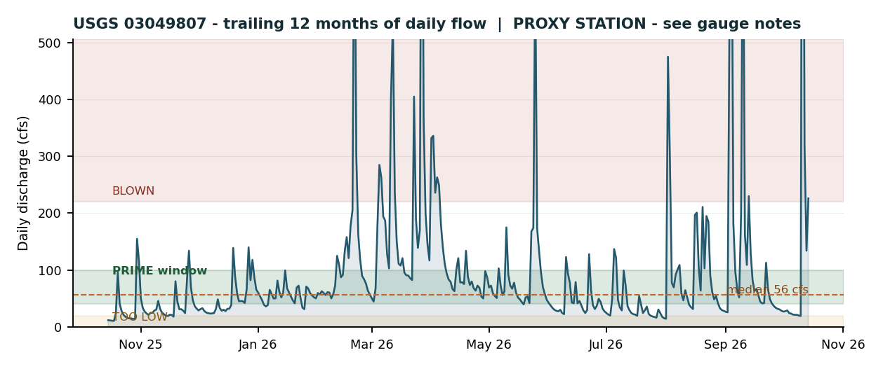
Live charts load with the gauge feed — until it answers, the trend above is the guide’s baked record (Wed Oct 14, 2026), labeled as such.
Daily mean flow for Wed Oct 14, 2026 — the latest full day in the guide’s gauge record. Checking the live USGS feed now…
Weather joins the verdict when the forecast feed answers — air temperature, wind and rain chance for the creek, and a lightning hold if storms are on it.
Verdict computed live from the flow band and the 24-hour trend — the same windows the full guide fishes by. It is a planning aid, not a promise: look at the water before you fish it.
The only guide that’s alive — verified daily, conditions called live, changes patched as they happen. Everything below the foundation was checked against reality on the date stamped above; the log shows the receipts.
Deer Creek, today: the call
One verdict, computed the moment you open this page: the live proxy gauge, the calendar, the stocking record and the owner’s rules for this water, fused. No website, book or PDF makes this call — they were printed before today happened.
- 1SR 910 bridge pools at Martin RoadOwner’s note
Top of the Delayed Harvest section — the fish stack here, at the head of the section by the stocking points.
- 2Campbell Road pull-off waterOwner’s note
The section's technical water — expect it low and clear: long leaders, 6X, small flies, first and last light.
- 3The winery hole on 910Owner’s note
Held fish last season — the secondary spot if the top two are busy.
- ×Skip: The golf-course walk (Rose Ridge bends)Owner’s note
Fished spring 2026: not one fish in that stretch. Long-shot water only — fresh stockers passing through, not a destination.
What the owner knows that the internet doesn’t
Access pins and hatch charts are public — anyone can scrape them. This layer can’t be scraped: it’s the owner’s own time on this water, recorded as dated field intelligence and corrected into the guide. When it contradicts the books, the books lose.
Last season (2025), the majority of the section’s fish were under Martin Road and the SR 910 bridge — the TOP of the Delayed Harvest section, not spread through it. The winery hole on 910 held a few fish.
What it changes: fish this section top-heavy — 910 bridge pools first, winery hole second.
Spring 2026: the golf-course stretch of the DHALO was fished and found with NOT ONE FISH in it — despite the old write-ups selling the golf-course bends as the section’s holdover home water.
What it changes: the golf-course end is a long-shot walk, not a destination. The section’s holdover story lives in the Campbell Road water and up top.
Rose Ridge Golf Course has been SOLD (2026). Public listings still show the longtime owner, so the sale is recent. The PFBC boundary keeps the course’s name, but ownership — and course-side access posture — has changed.
What it changes: access caution at access point 3 until the new owner’s posture toward anglers is known. Never park in the course lot.
The Campbell’s Run hole (Campbell Road water) usually runs LOW AND CLEAR. Technical spring-creek conditions are its normal state, not just a low-flow band.
What it changes: rig for it before you arrive — long leaders, 6X, small flies — instead of treating low-and-clear as a surprise.
The latest word on Deer Creek
A dated feed for this water only: condition reports, stocking confirmations, access changes. A downloaded PDF can never do this — this page is re-verified and re-fed as things happen. Last verified Wed Oct 21, 2026 — 12:27 PM ET.
- CONDITION2026-10-21
Anglers were on Deer Creek this morning — other vehicles parked along the stream (owner observation). Despite the company, still zero catch reports from Deer Creek anywhere. Consistent picture: the scheduled stocking drew anglers, the construction-degraded water gave them the same result.
Source: Keystoned Steel, on the water (Oct 21)
- CONDITION2026-10-21
OWNER CORRECTION + CAUSE, Oct 21: the mud is CONSTRUCTION SEDIMENT, not runoff. Construction north of the hole has ruined the fishing from the hole all the way down to the winery, and the water is still cloudy. The hole itself is NO LONGER DEEP — most of its water is gone (silted/filled). Until that construction stops flushing sediment, treat this whole stretch as degraded: stained water, a shallowed hole, and fish pushed out or buried under silt. This supersedes the 'fish sit tight in the deep holes' read in the report below.
Source: Keystoned Steel, on the water (follow-up, Oct 21)
- CONDITION2026-10-21
OWNER ON THE WATER, late morning Oct 21: fished the first 500 yards of Deer Creek. Water LOW and heavily MUDDY — thick stain, near-zero visibility (photos on file) — a real change from Oct 20's low-and-clear. NO fish seen or caught in that stretch. Honest read: a no-fish pass through 500 muddy yards does not settle the stocking question either way — in stain like this, stocked rainbows sit tight in the deep holes (Martin Rd / 910 bridge water), and the Oct 20 truck run stays verified-on-schedule with fish presence still UNCONFIRMED until a cleaner-water report exists.
Source: Keystoned Steel, on the water (photo-verified)
- STOCKING2026-10-21
Mid-morning re-check (9:45 AM): Facebook groups (Steel City Anglers, Pittsburgh PA Fishing Community, Pine Creek fly group, Steelhead Alley) and web/social sweeps still show zero Deer Creek posts since Oct 20 — no angler confirmation of fish in the water yet. The only stocking chatter anywhere remains Pine Creek (Oct 20). Status unchanged: PFBC run verified on the schedule (Pleasant Gap truck, Middle Deer Lake lot, 12:45 PM Oct 20, rainbows, no postponement posted) — fish in Deer Creek remain UNCONFIRMED until an angler report surfaces.
Source: Operator re-check — mid-morning, Oct 21, 2026
- STOCKING2026-10-21
Overnight check: Facebook fishing groups (including the local Pittsburgh-area groups), web and social sweeps turned up still zero angler reports from Deer Creek — no posts, photos or catch reports from Oct 20 evening through this morning. Status unchanged from last night: the Pleasant Gap truck run is verified on schedule (met Middle Deer Lake lot, 12:45 PM Oct 20, no reschedule marker), but the Section 3 stocking itself remains UNCONFIRMED until an on-the-water report exists.
Source: Operator verification check — early morning, Oct 21, 2026
- STOCKING2026-10-20
Evening check: five confirmation sweeps — PFBC, pennsylvaniastockedfish.com, Facebook, Instagram, Threads and Fishbrain — turned up zero angler reports from Deer Creek. The official run evidence: the PFBC page shows the Pleasant Gap run met at the Middle Deer Lake lot at 12:45 PM Oct 20 with no reschedule marker, so the truck ran on schedule — but with no Deer Creek-specific report, the stocking stays short of confirmed. Water low and clear (owner, on the water today).
Source: Operator verification check — evening, Oct 20, 2026
- CONDITION2026-10-20
Water low and clear.
Source: Keystoned Steel, on the water
- STOCKING2026-10-20
Fall rainbows into Section 3 today (Pleasant Gap hatchery). No stocking-day reports or photos had surfaced by the mid-afternoon check — confirmation pending. Watch this log.
Source: PFBC schedule; operator check
- ACCESS2026-10-20
Rose Ridge Golf Course sold (2026) — access caution in effect at the Delayed Harvest section's lower boundary. See Field Intel.
Source: Owner field intel
- EDITION2026-10-20
Interactive Edition published: The Call (live daily call), Field Intel and this field log layered over the verified foundation. Print PDF bundled — regenerated Oct 20, 2026.
Source: Keystoned Steel
Verification log — the receipts
Every check the operator ran on this water, what it found, and where it came from. Uncertainty is printed, not hidden.
| Date | Check & result | Source |
|---|---|---|
| 2026-10-20 | Fall stocking date — Section 3 (Delayed Harvest) PFBC record lists rainbows stocked today, Oct 20, from the Pleasant Gap hatchery. Truck run verified on schedule — PFBC page shows the Pleasant Gap run met at Middle Deer Lake lot 12:45 PM Oct 20 with no reschedule marker; no angler reports from Deer Creek itself yet. | PFBC stocking record (fbweb.pa.gov); operator verification check, Oct 20, 2026 |
| 2026-10-20 | Proxy gauge — USGS 03049807, Pine Creek at Etna Live and falling: 84.9 cfs at 12:30 PM ET, 80.3 cfs at 1:45 PM ET — Prime band on the guide's proxy windows. Deer Creek itself has no gauge: all five USGS inventory sites on the creek (03049645, 03049646, 03049648, 03049649, 03049650) return no discharge or gage-height series. | USGS NWIS instantaneous values, Oct 20, 2026 |
| 2026-10-20 | Owner condition report vs. the proxy Owner on the water reports Deer Creek low and clear while the proxy reads Prime. Both stand — the proxy times the trip, your eyes at the SR 910 bridge call the tactics. The guide's two-step check working exactly as designed. | Owner field report, Oct 20, 2026 |
| 2026-10-20 | Ground change — Rose Ridge Golf Course Course sold in 2026 (owner intel; public listings still show the longtime owner). Access caution patched into this guide at the Delayed Harvest lower boundary; course-lot parking removed from the access copy. | Owner field intel, reported Oct 20, 2026 |
| 2026-10-15 | Foundation data Access pins checked against PFBC GIS records; Delayed Harvest rules against the PFBC Summary Book (Southwest Region); stocking history against PFBC records; gauge status against the USGS NWIS station inventory. | Guide data file (last_updated 2026-10-15) |
Today's plan
One mission, computed for Tuesday, October 20 from the flow band, the season and the solunar clock. On the live page it recomputes in your browser every day.
Fish it — the species checker, bite clock & what-if lab
This is the part a search engine can’t hand you: the guide’s own data, computed against today’s water. Pick a fish and read its window, check the clock, then break the conditions in the lab before the creek does it for you.
Species turn-on checker
Every fish on this water, scored live from the flow band, the month, the water temperature and the trend. Tap one for its window and the fly that matches right now.
Best window today: Dawn — 7:05 AM–9:05 AM
Throw now: Small jigs and spoons from the park shorelines; slow spinners in the cold months
Where: Deer Lakes Park lakes
Water temp read: 54°F (typical for the month — the live gauge read replaces it when the feed answers)
Bite clock — today
Solunar major and minor windows over the day, with the dark hours shaded. Green is a major, rust a minor.
Minor windows: 1:06 PM–2:06 PM · 1:30 AM–2:30 AM
Sunrise 7:35 AM · Sunset 6:32 PM · moon age 9 days. Solunar windows are the traditional approximation, computed on this page — a planning aid, not a promise.
Weather chart loads with the forecast feed.
Bite clock computed on this page for today · the gauge trace joins it when the USGS feed answers.
What-if lab
Slide the water around and watch the verdict and every species tier recompute. Planning a Saturday on a Tuesday? This is how. The lab never touches the live verdict up top — that one always runs on the real gauge.
At the baked reading — 226 cfs, Blown out band. Move a slider and this recomputes.
Current conditions
Proxy gauge: USGS 03049807 — Pine Creek at Grant Avenue at Etna. Deer Creek has no gauge of its own — every reading on this page is the Pine Creek proxy, labeled as such, and the creek itself has the last word at the SR 910 bridge.
Flow windows — where 226 cfs sits
Deer Creek is UNGAUGED - verified against the USGS NWIS station inventory in October 2026 - all five inventory sites on the creek (Bairdford 03049645, Dorseyville 03049646, Little Deer Creek 03049648, Rt. 910 near Cheswick 03049649, Harmarville 03049650) return no discharge and no gage-height series, current or historic. Windows are therefore keyed to the nearest honest proxy - Pine Creek at Grant Avenue at Etna (USGS 03049807), the adjacent basin immediately west, whose gauge drainage (57.3 sq mi) closely matches Deer Creek's (about 51 sq mi at the Harmarville site, about 52 at the mouth). Bands are scaled slightly under Pine's own windows because Deer Creek runs a touch lower and flashier than Pine at the same reading. Derived working bands - always confirm color at the SR 910 bridge before fishing.
Gauge page: USGS monitoring location 03049807
Live chart loads with the USGS daily feed — until it answers, the chart below is the guide’s baked record (trailing 12 months, Oct 2026 gauge record), labeled as fallback.
Fall stocking — Tuesday, Oct 20, 2026
Deer Creek Section 3 — rainbow trout into the Delayed Harvest water in Gibsonia (SR 910 at Martin Road down to the Rose Ridge Golf Course boundary — the upper creek, not Cheswick). All three Deer Lakes Park lakes (Lower, Middle, Upper) are stocked the same day. Walk in from Campbell Road — golf-course-lot parking is a thing of the past; do not park on the course. No meeting point is printed here on purpose — check the current PFBC schedule the week of the stocking.
Delayed Harvest Artificial Lures Only — the rules that matter
About Deer Creek
Deer Creek is the Allegheny County stocked creek most anglers drive past. PA DEP listings carry about 10.5 miles of main stem (Cold Water Fishes designated use), rising near Bakerstown and Gibsonia and running south through Indiana Township to its mouth on the Allegheny at Harmar - roughly 52 square miles of watershed, drained by tributaries like Little Deer Creek, Long Run and Rawlins Run. Its modern identity was made in two pieces. Up top, PFBC carved out 1.9 miles of Delayed Harvest Artificial Lures Only water from the SR 910 bridge at Martin Road down past the Campbell Road bridge to the lower boundary of Rose Ridge Golf Course - artificials only, a June-to-Labor-Day harvest window, and spring, in-season and fall stockings (browns, rainbows and goldens from Pleasant Gap) that turned a suburban creek into a holdover fishery with a local reputation for outsized browns. Down below, the middle creek runs through Indiana Township's 59-acre Emmerling Community Park - the stocking trucks' meeting place, with trails and a wooden footbridge on the water - and the greenway around it grew by 266 acres in 2025 when the Deer Creek Conservation Project moved from the Allegheny Land Trust to the Game Commission. The creek carries a coal-country past - DEP's impaired-waters listings have flagged segments for abandoned-mine-drainage metals over the years, which the watershed groups keep chipping at. And it is, completely, ungauged - the USGS keeps five inventory pins on it and publishes flow from none of them, which is why this guide borrows Pine Creek's gauge one basin west and tells you to confirm everything with your own eyes at the SR 910 bridge.
Regulations
- Delayed Harvest Artificial Lures Only: 1.9 miles, from the SR 0910 Bridge at the T-678 intersection downstream to the lower boundary of Rose Ridge Golf Course (PFBC Summary Book, Southwest Region). Artificial lures only - no bait or baitfish may be used or possessed in the section. Open to fishing year-round; trout may be kept only from June 15 to Labor Day (minimum 9 inches, creel limit 3); catch and release at all other times.
- The rest of Deer Creek is a PFBC Stocked Trout Water under standard stocked-trout seasons - closed to fishing March 1 to opening day, regular season creel 5 (7 inches minimum), extended season creel 3. The Delayed Harvest section stays open through the March window.
- A valid PA fishing license and trout permit are required on the creek; the Combination Trout/Lake Erie permit also covers this water.
- At the mouth you are on the Allegheny River: river seasons, sizes and creel limits apply there, not creek rules - season closes in mid-March, which is exactly when the mouth fishes best. Check the river tables before you keep anything.
- Respect the corridor: the DHALO runs past a golf course and homes - stay in the creek corridor, never cut across the course, park off the pavement on Campbell Road, and pack out line. Emmerling Park is sunrise to dusk with posted summer-camp closures.
- Summaries for planning only: check current PFBC rules for the exact water and date you fish.
Sources & honesty notes
- PFBC Summary Book, Southwest Region regulated trout waters - Delayed Harvest Artificial Lures Only listing verbatim for Deer Creek (1.9 miles; SR 0910 Bridge at T-678 intersection downstream to the lower boundary of Rose Ridge Golf Course) and the DHALO rule structure (artificials only; harvest June 15 - Labor Day, 9 inches, creel 3; open year-round).
- PFBC trout stocking records (fbweb.pa.gov, GIS_Key 6063-3, "Deer Creek 3") - Section 3 endpoints with coordinates (SR 0910 bridge at Martin Road, 40.6130/-79.9002; lower boundary of Rose Ridge Golf Course, 40.6042/-79.8782); 2026 stockings March 3 and April 14 (brown, rainbow, golden) and October 20, 2026 (rainbow), Pleasant Gap hatchery; Section 4 stocking and Emmerling Community Park meeting place from PFBC schedules.
- USGS NWIS station inventory, October 2026 - Deer Creek sites 03049645, 03049646, 03049648, 03049649 (drainage 49.1 sq mi) and 03049650 (51 sq mi) - no discharge or gage-height series at any site, daily or instantaneous. Proxy gauge - USGS 03049807 Pine Creek at Grant Avenue at Etna (drainage 57.3 sq mi).
- USGS GNIS via Wikipedia, Deer Creek (Allegheny River tributary) - source (40.6844, -79.9025) and mouth at Harmar Township (40.5353, -79.8394, elevation 725 ft), tributary list; PA DEP Deer Creek TMDL / 303(d) listings - main-stem segments of about 10.5 miles, Cold Water Fishes designated use.
- Indiana Township parks department - Emmerling Community Park - 59 acres, 152 Cove Run Road, trails along Deer Creek with a wooden footbridge, sunrise to dusk, summer-camp partial closures mid-June through July (Mon-Fri 8:00 AM - 1:30 PM). PA Environment Digest, April 22, 2025 - 266-acre Deer Creek Conservation Project (Allegheny Land Trust to PA Game Commission) expanding the Emmerling greenway.
- Outdoor News, Southwest PA fishing reports (2014) - smallmouth and rock bass at the mouth of Deer Creek; 43-inch muskie from a nearby Allegheny River back channel. Dark Skies Fly Fishing (local access account) - Campbell Road pull-off and stocking points, golf-course-lot parking discontinued. PA regional hatch charts (published) - typical western PA hatch windows.